


blanchemer

gerard70
User
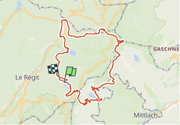

Length
23 km

Max alt
1355 m

Uphill gradient
979 m
Km-Effort
36 km

Min alt
921 m

Downhill gradient
981 m
Boucle
No
Creation date :
2024-06-13 07:15:38.249
Updated on :
2024-06-13 15:11:40.004
5h49
Difficulty : Medium

FREE GPS app for hiking
 SityTrail
IGN / Geographical institutes
SityTrail Plus
The world is yours!
About
Trail Walking of 23 km to be discovered at Grand Est, Vosges, La Bresse. This trail is proposed by gerard70.
Positioning
Country:
France
Region :
Grand Est
Department/Province :
Vosges
Municipality :
La Bresse
Location:
Unknown
Start:(Dec)
Start:(UTM)
349027 ; 5320361 (32U) N.
Comments